Saturday 11 September 2010

London LOOP Challenge - Day 1 - Erith Riverside to Crayford

Last weekend, we didn't do a walk - shock, horror. Usually, with me, the first time I don't pursue a hobby, it's the beginning of the end but I am pleased to report that this time, this is not the case. We did another walk today and have set ourselves a challenge into the bargain.

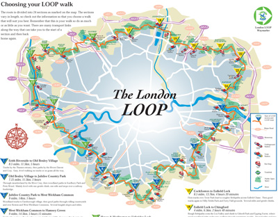
While doing the Shuttle Riverway walk, we noticed that it intersected with the Green Chain walk. I was intrigued enough to look it up and in the process discovered another walk called the London LOOP. You can read all about it here, but to put it in a nutshell, it is a 140 mile walk around London, through the greenest and most rural places the designers have been able to find. The idea is to highlight how much countryside we have inside this great city and also to have a walk that Londoners can do with the help of a Zone 1-6 travelcard and their own two feet. No car needed.


This sounded really appealing as Claire was at a wedding last weekend and chickened out on the walk today (Claire, hope you're reading this!) She has promised to join us on the next one (after I bullied he into saying yes!) but since Arup and I are confined to public transport without her, the London LOOP sounded really appealing to us. Also, the starting point of the loop is local to us which makes it feel even more like it's a walk that we should do.

Cutting a long story short, Arup and I have challenged ourselves to walk the complete London LOOP over the course of the next 1-2 years. Not the most challenging timescale perhaps, but our ojective is really just to finish it, however long it takes.

Today was our first day. Now the website divides the walk into 24 sections of between 4-10 miles and my book divides it into 15 sections of about 8 miles. But the beauty of this walk is, it provides links to nearby train stations so you can stop at various points along the way. So though the first section should have been Erith to Old Bexley (8.4 miles), we knew we would be stopping either at Slade Green station (4 miles) or Crayford (6 miles).

Arup and I have fallen into some walkday routines - we carry sandwiches (especially for afternoon walks) - peanut butter and jam for me, onion relish and butter for him, three packets of Snack-a-Jacks, two bars of Nature Valley cereal bars and two bottles of water. Oh and we have burgers afterwards as that's the easiest thing to make when we get home exhausted.

Anyway, back to the walk.

We started near Erith station and walked along Erith pier. The Thames at this point is very wide and impressive but not particularly pretty.


Working in central London and going in to Charing Cross, means I cross the Thames twice a day at a point I think it is very pretty. So while it was nice to see and quite a shock how close it was to us, we didn't spend too long loitering along the pier.

Erith council has obviously worked hard to make this a nice place to visit but the sign saying life buoys weren;t available due to vandalism summed up the uneasy balance between the smart suburb Erith is trying to become and the slightly rough area it has been in the past.

Nice riverfront apartments
What was pretty cool though was being able to look across the Thames at the point where the London LOOP finishes - we'll get there sooner or later!
Our destination awaits!


Leaving the pier was the only point at which we got slightly lost (we tried to leave too early along it!) but eventually we figured out we were meant to leave along the road behind the huge Morrison's not in front of it. The next bit was a slightly bizarre walk along a main road between various scrap metal yards - including one called 'Pulp Friction' :).

At the end of the road, the Crayford Marshes suddenly began and they were quite a surprise. I've seen hills and dales and valleys from the trains and I've often marvelled at the variety of landscape the UK has, but I don't think I've ever seen a marsh let alone walked along it.

It was a very different experience espacially since we seemed to have it to ourselves, except for the horses grazing.

My idea of a marsh is solely from the Lord of the Rings films with dead people floating spookily underwater. There were no dead people and no water on the Crayford marsh (not that I could see anyway!) though as we walked only on the elevated causeway, it is possible what looked like solid ground lower down was not as solid as it looked. It was however a vast expanse of shrubs and heath-like land and quite unique in my experience.

Erith Yacht Club in the distance

The two faces of Crayford Marsh - ponies and industry

When we got to the end, we were greeted by the Darenth Creek Flood Barrier, which my book described as a 'Tower Bridge made of concrete'.

 Er no, not really unless I can descibe the letter H as a 'Tower Bridge made of lines'. But anyway, it prevents the local area from flooding and can operate on very little power so it's a good guy (if a bit ugly) in my eyes. Plus it had a very charming bench not far from it where we had a picnic.


A dragonfly - after Arup sat on it

We then walked along the opposite side of the marshes, with the Darenth river on our left.

Remember the Cray walk we did a few weeks ago? Well the Shuttle meets the Cray at Hall Place, the Cray meets the Darenth and the Darenth meets the Thames at the flood barrier. It's quite cool actually seeing the local river system from the ground. This section of the walk is a bit strange with a pretty river on the left and scrapped cars on the left but then I guess rivers have always been more than pretty bits of water - they serve an important purpose for trade and industry and long established industrial areas can't just move when technology improvements mean being near a river is no longer necessary.


After a while the scrapyards disappeared and though we could hear cars (and gunshots from the shooting range across the river!) and see industrial estates in the distance, for the most part it was a really beautiful, countryside-like walk.

There's a road up there somewhere
Eventually we got to the place where we would need to turn off for Slade Green station. We sat on a bench and pondered about it but we both wanted to go on.

More riverside walking later we arrived at the junction of the Darenth and the Cray, where we had another rest and admired the surroundings.

Darenth on the far side, Cray near the camera
From this point on the LOOP follows the Cray so in effect we were completing the Cray Walk from the opposite direction.

Some time later, we go to the end of the trail and had to go through a bit of industrial estate, under a railway bridge and across a main road until we got back onto a track next to the Cray. It started out feeling suburban but got back into countryside mode as we proceeded.

Here be dragons
It really is quite amazing how much green space and countryside there is within these Greater London suburbs.

There were people fishing and little boys swimming but on the whole not a lot of people seemed to be using the trail.

At the end of the trail we walked through a residential street whose houses have the Cray river in their backyards.

There were dinghies tied up at their own personal landing stages - what an amazing place to live. And the funny thing is from the street the frontage of the houses is really ordinary - but the back- wow!

At the end of the street, the trail continued along the river. This time we seemed to be walking past the backs of people's garages and sheds which was sad because the Cray is still very pretty here and though the path runs along a higher level, there are lots of rough steps down to the river bank.


By this time I was getting really footsore so we had a rest on some of the steps and really enjoyed the secluded tranquil atmosphere.

At the end of the path we came out onto a main road and hey presto, we were back in civilisation on Crayford High Street.

We walked through a tiny but pretty park, visited Sainsbury's for tenderstem broccoli to go with our burgers, caught the bus and went home.

Overall, we must be improving at walking because we did 6 miles and Arup wasn't tired at all and I - well I wasn't tired but my feet were really sore and I was really struggling at the end. My excuse is that I have flat feet but I'm starting to get the feeling that 6 miles may well be my limit. Still, as people who know me will attest, the fact that I can walk 6 miles is not something they would have expected.

So that's our LOOP journey begun - I really enjoyed this section and am looking forward to the next one. Watch this space for more updates.

Monday 30 August 2010

Sunday walk 4 - Shuttle riverway

Yesterday we did the Shuttle riverway walk and it was the most challenging one we've done by miles! Claire was visiting her mum over the bank holiday weekend so Arup and I set out alone again. This time we chose the Shuttle riverway walk - the Shuttle is a rivulet that feeds into the Cray near Hall Place. We decided to walk it from it's source - in Avery Hill Park, in Eltham - to where it meets the Cray, at Hall Place. This was the second walk we found on the Bexley council website and this one said it was 'about 5 miles long' and fully signposted.

The weather forecasts weren't great so Arup decided to buy me some proper walking boots so that i wouldn't go sliding all over the place in the mud. I chose these from Millets and against the lovely Simon's advice, chose to break them in on the walk rather than around the house.

Having overslept and generally been very lazy on Sunday morning, we got to Avery Hill Park on the bus, arriving at 1pm. Our first hurdle was trying to find the first Shuttle riverway sign as we had no idea how to get to the point in the park where the walk officially begins. With a little help from a passerby, we followed the Green Chain walk into the park until we found the first sign for 'our walk'.


Green chain walk into Avery Hill Park
This sign informed us that the walk was 5.75 miles long - 1 mile longer than any we've done before. I was a bit concerned but after all it was only a mile - how bad could it be?

Avery Hill Park is a big, beautiful park which is now part of the grounds of the University of Greenwich.


There were lots of dogwalkers, dad's with children, and football teams around and we enjoyed people watching as we walked. Which is possibly why we missed the sign that told us where to leave the park for the walk. A half mile detour later, we were back on track, but my feet were starting to get sore and we still had almost 5 miles to go!

The next part of the walk was mainly through residential streets of Eltham and the sun was beginning to get quite hot. I was getting fed up with the heavy boots and the fact that we'd been walking for AGES and we still hadn't seen hair nor hide of the blasted Shuttle! Finally, I gave up and took advantage of a grassy verge to change back into my trainers (luckily, we'd had the foresight to bring them or it would have been a very short walk!)

A little further and finally, the Shuttle made an appearance. What a wimpy little river!


Nevertheless, it cheered us up and the clouds had come up making it cooler, so we were in a better temper. Soon afterwards, we entered a park, which, while not exactly wilderness, was at least green and not a residential street.

To be honest, the next bit is a bit of a blur in my memory as for some reason I found the walk very hard this time and it seemed to go on for ever along more residential streets. By this time it was pouring with rain, my trainers were getting wet and we were hungry and miserable. Eventually, we came out onto Penhill Road, which I recognised from house hunting last year. We plodded up it, reaching the roundabout and realised we hadn't seen a sign for some time. The absolutely useless map from the council website wasn't much help except that it seemed to indicate we should be walking along the river. We very nearly gave up then and took a bus home. But we knew we hadn't walked even halfway so we forced ourselves to go back to the last place we'd seen the river (another 1/4 mile detour) and scan the place for signs. None. We set off along the river, hoping we were going in the right direction when we met a lovely lady walking her dog who told us we were in completely the wrong direction and needed to cross the road and follow the river that way. Needless to say there were no signs on the other side of the road either.

Still, the rain had stopped so we ate our sandwiches and crisps in companionable exhaustion. It was actually a rather pretty place with enormous trees and few people.


Our break done with, we kept going through parks and more parks until we reached Bexley Woods. Now this was the last bit of the second section of the walk so we cheered up considerably. It is a very small wood if you walk straight through, but hey a wood practically in our back yard isn't to be sniffed at.

Onwards we went. I was really starting to flag now but kept going on willpower. There were more residential streets and a few green riverside walks. The rest of it wasn't very interesting to be honest and finally we found ourselves right next to the A2. We walked parallel to the A2 for what felt like miles and I could see the desparation in Arups's face as he watched me struggle and stumble on. He was worried I would just give up and there was no way to get help there despite being in the middle of civilisation. We finally made it to the dead end of Upton Road South where I collapsed in a heap (well sort of) and Arup ruled that we would find the nearest bus stop and go home. Which we did.

Having calculated, with all the detours and mistakes, we must have walked at least 5.75 miles even if we didn't get to Hall Place (we got pretty close though - it as only about a mile from where we took the wrong turn). It felt like a lot more though and was hard or both of us, though Arup was wonderful in helping me on. It's told us we're not quite experts yet - either at walking or at map reading but it hasn't dimmed our enthusiasm and we'll be at it again next weekend. See you then.

Sunday walk 2 & 3 - Cray river walk

The past three weeks haven't been the best for walking mainly because we haven't been able to get as far out into the countryside as we'd have liked to. The weekend after Meopham, Arup was working on the weekend and Claire and I decided to stay closer to home for our walk. The Cray is a local river (rivulet more like it) that joins the Thames near Erith.

The Bexley council website promised that it was a signposted walk so despite the lack of clear directions on the guide, we decided to give it a go. The whole walk is about 10 miles but we decided to walk from Foots Cray Meadows where the walk begins to Hall Place and then walk home - a total distance of between 4.5-5 miles.

Note: Arup and I did the same walk the following week because Claire was not well and I wanted to show Arup Foots Cray Meadows. The photos are from both walks.

We took the bus to Foots Cray and after dutifully taking pictures of All Saints Church because the guide mentioned it, entered Foots Cray Meadows.

All Saints Church

Now, I've lived in the Borough for close to three years and Claire has lived here all her life but neither of us really realised what a green borough it is. Take Foots Cray meadows. I'd heard of it but never really knew what it was and Claire, who had been there in her misspent youth (!), hadn't really noticed how pretty it is.

Foots Cray Meadows is a local nature reserve and a very popular spot for dog walkers. The Cray flows down the middle and the Cray walk follows it pretty closely. It isn't the biggest of rivers, but it is pretty and wooded and a lovely surprise in the middle of suburbia.

First view of the Cray
Signs - these are so welcome when you're sure you're lost!

The five arch bridge is a great spot to stand and admire the view and feed the mute swans and ducks.


Five arch bridge


When I did the walk with Arup, he was so happy to see the dogs and made friends with one. He would love a dog of his own but sadly with both of us working and me being asthmatic, it isn't really a possibility.

Arup's new friend

Bits of the walk are really Indiana-Jones ish because you can walk very close to the river's edge battling your way through the undergrowth. I got stung by some sort of nettle and it was itchy for days. Guess it's my first walk-wound!


The meadows are about 1.25 miles long if you walk along the river and at the end you have a choice of going to Hall Place via Bexley village (2 miles) or via Churchfield wood (3.25 miles).


Claire and I went via Bexley as we were hoping to get the borough's best ice cream at the Italian deli on Bexley high street. Sadly, it was closed and we were forced to get a drink at the pub instead. Which was quite funny because we were asked for ID and we didn't have any other than our 30+ faces! Unfortunately that didn't wash and we had to give the next pub our custom, which turned out to be worth it as we overheard a conversation in which the lady was asked if she'd ever have cosmetic surgey. She said 'I might do if my boobs fall down but I think they're quite nice at the moment. What do you think, love, don't you think they're quite nice?' No, sorry, I didn't get a picture of her!

The rest of the walk was a bit boring since it was just along he bus route that we often take. Hall Place was lovey as always and we walked around the gardens and greenhouse before heading home.

When I did the walk with Arup, we took the other route from the end of Foots Cray meadows but after a nicer, more wooded walk initially, we found ourselves on North Cray road and ended up walking all the way to Bexley along it. If there were signs taking us anywhere else, we either didn't see them or misinterpreted them. It was a longish walk but we were so disappointed by it (other than the quite lovely houses we admired along the way), we consoled ourselves with a picnic when we got to Hall Place. The rain, which had been promised, finally came while we were there but I can report that our new waterproof jackets did very well in protecting us.

On the way home, we went up Gravel Hill and took a different way home just to make things a bit excting. Oh and we have now established a walk night routine- burgers for dinner!